


Yinderser is a trekker’s paradise that every alpine explorer would appreciate.
by Shahnawaz Khanday
On a sultry July afternoon, I sat with my friends and colleagues in the canteen of our workplace flirting with the idea of visiting Yindersar- a rarely explored alpine tarn located high up in the Astanmarg meadow of Pir Panjals in Kulgam district. I had been ‘visiting’ this place for some months, albeit on Google Earth, trying to find the easiest, shortest but not entirely unchallenging trail. And it was not long before we found ourselves packing up for a day trip to this relatively lesser known and still lesser explored Yindersar/Indersar alpine lake on July 28, 2020.
Yindersar is an alpine lake located atop Astanmarg – an expansive meadow at an altitude of 12800 ft.
Contrary to what I had surmised from the Google Earth, the trek proved to be an exceptionally arduous one. The first portion of the trek, from Aherbal to Kongwattan (7 kms approx.), as always, was completed playfully. We set off for Kongwattan at around 7:20 am from Gurwattan, Aherbal and reached Kongwattan at around 9 am. Once we were at the far end of Kongwattan meadow, where the trail head of Astanmarg is located, the climb started to get difficult with each step we took. Astanmarg rises quite sharply and suddenly several thousand feet (nearly 5000 ft.) from Kongwattan.
There is no proper trail to the top of the mountain from Kongwattan side. As such we were forced to trek up the nullah that offers a relatively easy way to reach the top of Astanmarg. We had some friends who were on their maiden trip to such high altitude locations. They had to face such a hard climb on their first trip but, kudos to their determination, they climbed on and on recuperating with frequent rests after every few minutes though! The rocks in the nullah provided the footholds for us as we inched higher and higher. We might have climbed some 1500 feet fathoming an end to the torture of pushing up against the gravity when suddenly we found ourselves looking at a steeper ridge. We had to take a detour of a couple of miles eastward to reach the top from a less steep shoulder with less scree. It consumed another two precious hours and drained more energy. Still we lumbered on. The group heaved a sigh a relief on reaching the top of Astanmarg at around 1:45 pm. But wait, it wasn’t the top. It wasn’t long before we realized that the point we had arrived at was only a plain that rested below another shoulder – which indeed wasn’t apparently as steep as the one we had just overcome with great difficulty.
We decided to take lunch and give our bodies the much-needed rest. While having lunch, I could see that most of the co-trekkers were in no mood to go further as the difficult terrain had taken a toll on their resolve and all they wanted to do was doze off . After lunch, and some of us saying our afternoon prayers, it took a lot of cajoling and coaxing to convince two of my friends, Nayeem and Bilal, to get up and get going. Notwithstanding my persuasions, four of our co-trekkers decided to call it a day then and there, and rightly so, as we later realized the destination was still faraway.
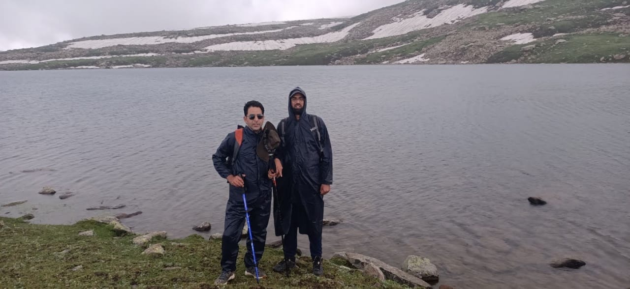
It was from there that Nayeem, Bilal and I, summoning our last ounce of energy, decided that there was no going back without seeing Yindersar. It took us a good two hours, climbing shoulder after shoulder, moderate ones though, to finally find ourselves in a meadow which overlooks Kongwattan and Sekijan meadows to the north, a savage rock wall to the southwest with majestic Kousarnag located behind it and mighty peaks of Bramsakli to its southeast. It was here that I, aided by a Google Earth screen recording, sensed that we were not far away from Yindersaer. Trekking up the final shoulder to the west of the meadow, we savoured the first glimpse of Yindersar at around 4:40 pm, visible through a blanket of clouds which grew darker within seconds as we had to take out our rain gear.
It was raining heavily even before we could get to the banks of Yindersar. We nevertheless got nearer and touched the shores of the lake whose serene waters soothed our eyes and souls. As often happens in mountains, the clouds took only a few minutes to go away and allowed us to lose ourselves to the mysterious beauty of the tarn. We clicked some photos and shot some videos as souvenirs. The inexpressible joy and satisfaction of reaching the destination after braving all the odds cannot be articulated enough. Mindful of the length and difficulty of the trail down the mountain and unpredictable nature of the weather at such altitudes, we beat a hasty retreat at around 5:20 pm. On our way back, we chose to climb down via a nullah to the northwest of Astanmarg which would take us to the Kousarnag trail culminating at Sekijan. The trail overlooks the Sekijan-Mahinag trail offering some unprecedented and fascinating viewpoints of Mahinag.
We were chased by a Bakerwal dog on a steep ridge. Our hiking poles came in handy to ward off the animal who relentlessly charged at us for quite some distance. We had to do a fair bit of rock climbing/ descending sans any equipment to get down to the base of the mountain and set ourselves on the proper trail. After spending an hour or so, literally on the edge, we found ourselves, much to our relief, close to the track which leads to Kongwattan. In an hour or so from here we almost ran to Kongwattan and onwards to Aharbal where we reunited with our friends at a wayside tea stall. It was truly one of the most arduous treks I have personally undertaken thus far. It threw up challenges and sprung beautiful surprises all through the trail.
Shahnawaz Khanday is assistant professor with J&K’s Department of Higher Education and an avid trekker who also loves to read and travel.


